
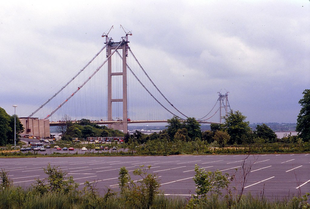
Stand on the Yorkshire bank and look across at the two towers that carry the Humber Bridge. On every drawing I have seen they look like a parallel pair, two straight verticals rising out of the estuary mud. They are not parallel. The reason is that both of them are exactly vertical.
A plumb line hung from the top of either tower points, as every plumb line does, at the centre of the earth. Two lines that both point at the same centre cannot run parallel to each other. They converge as they go down, so they diverge as they go up, and over 1,410 metres of open water with towers 155.5 metres tall the gap becomes a real number.
The Humber Bridge Board's own statistics page puts it plainly: the concrete towers were built to be 36 millimetres further apart at the top than at the bottom, to allow for the curvature of the earth. I ran the sum myself from the span and the tower height, treating the earth as a sphere of the standard radius. It came out at about 34 millimetres, close enough to tell me the figure is the right shape. I could find nobody who claims to have gone up with a tape and measured it, and one physics writer who went looking concluded the same, so it is a calculated consequence of a decision rather than a measurement, and worth saying so.
How the Humber towers went up
The decision was the thing. Freeman Fox and Partners, with Bernard Wex credited for the design, chose concrete towers rather than the steel plate they had used on the Severn and the Bosporus, and Chris Bradfield, who was on the design team and wrote it up for the Institution of Structural Engineers, says the reason was the anticipated cost of steel. Historic England's listing calls it the first use of concrete towers on a suspension bridge of this scale. Concrete towers cannot be fabricated in a yard and bolted true. They are poured in place, and every metre of height has to be plumbed as it rises.
They rose by slipform. A climbing shutter was jacked upwards while concrete was poured into the top of it and set beneath, so that each leg grew as a single unbroken pour. The Hidden Histories trail on the East Riding Archives site says the Hessle tower took 19 weeks at an average climb of 76.4 millimetres an hour, which Bradfield rounds to about four months. Think about that rate. A shutter moving at the speed of a minute hand, day and night, with men on the platform checking plumb and line as it went, and no way to come back and correct a lean once the concrete below had hardened.
Then the south side went wrong. The Barton pier sits in the river on two caissons, each about 24 metres across, sunk through soft alluvium to the Kimmeridge clay roughly 36 metres below the river bed, figures that Bradfield and the trade press agree on. Tidal streams scoured the sand inside the cofferdam where the cutting edges were built. Skin friction fought the grabs.
Then, in Bradfield's account, a sand lens under artesian pressure sent one caisson sinking faster than anyone could control, and the pier had to be redesigned and ballasted with steel ingots borrowed from British Steel at Scunthorpe before the caissons would bottom out. Wikipedia dates the artesian strike to March 1975 and says the Barton tower added three years to the job.
Having lost the time, they recovered what they could. The Barton legs were slipformed to full height, the top crossbeam cast, and the tower top handed to the steelwork contractor before the three lower crossbeams were even built. The trail puts the Barton slipform at about ten weeks. The cable saddles went on each leg at a setting-out level Bradfield gives as plus 162.5 metres, and were deliberately placed a little landward and jacked into line part way through spinning, because the cables would pull the towers as they tightened.
What the published accounts do not tell me is how the surveyors kept two legs of a slipform plumb through 155 metres of climbing. Nobody wrote down the instruments.
What the record does make clear is that the towers were plumbed to the local vertical at each pier, not aligned to each other across the estuary, and that choice is the whole story. A tower that is truly vertical carries its load straight down through its own foundation. A tower leaned a hair off true to match its twin a mile away would carry a tiny, cumulative angle through every one of those metres. They chose the earth over the drawing board.
What it cost them
The honest columns on the Humber side are not flattering. Work began on 27 July 1972 and the bridge opened to traffic on 24 June 1981, with the Queen cutting the ribbon on 17 July. The Institution of Civil Engineers and the Humber Bridge Board put the construction cost at 98 million pounds of the day, and the usual figure with interest counted in is 151 million. The early estimate had been roughly 28 million, the heritage trail noting that the final bill came in 70 million above it, through a decade of high inflation, the steel shortage of 1973 that the New Civil Engineer says delayed the temporary works, and the technical difficulties and poor weather the trail blames for four years of delay.
The debt outlived everybody who built it. A Department for Transport statement in July 2011 put what the Board owed the government at 332 million pounds, long after the interest had been suspended and deferred. The government cut 150 million from it that year so the car toll could come down to 1.50 pounds. The ICE says taxpayers are still owed more than 150 million. For 17 years it was the longest single span in the world, until Japan's Akashi Kaikyo took the title in 1998, built by more than a thousand people at the peak with no second chances in the concrete.
The same sum, three times larger
The record Akashi took in 1998 moved again on 18 March 2022, when the 1915 Çanakkale Bridge opened across the Dardanelles with a main span of 2,023 metres, 32 metres longer than the Japanese bridge. Its towers are steel, 318 metres to the cable saddles and 334 to the ornamental tops, the 318 chosen to mark 18 March 1915 and the span to mark the centenary of the Republic. Run the Humber sum on those figures and the two Çanakkale towers, if each is truly vertical, lean apart at the saddles by about 100 millimetres. Nobody at Çanakkale has published that number that I can find, and I would not expect it, because for them the curvature of the earth is not a curiosity. It is already inside the survey model.
In the 1970s the surveyors on the Humber plumbed each tower to its own local vertical with the instruments of the day and let the geometry fall out. At Çanakkale the towers were positioned against a satellite reference frame that already knows the earth is round, and the question became not whether the towers agreed with the earth but whether they agreed with the drawings to within a fraction of a millimetre.
How the Çanakkale towers went up
The towers were not poured. They were made in a yard. The conference paper on the design of the towers for the International Association for Bridge and Structural Engineering describes an H-shaped tower of closed steel boxes, each leg inclined, 11 by 10.5 metres at the base narrowing to 8 by 7.5 metres under the saddle, built from 32 erection blocks per leg. The Turkish press counted them going up block by block, 24 of 32 placed when the towers stood at 230 metres. Çimtaş, the ENKA subsidiary, fabricated the permanent steel at its yard in the Kocaeli free trade zone and shipped it down on its own vessel.
Each block was then lifted by one of two Marr M2480D tower cranes, each weighing 600 tonnes and brought a kilometre offshore on a floating crane, climbing with the tower to a final height Marr gives as 328 metres. Engineering News-Record reports a 155-tonne block going into place at 318 metres in about 30 minutes. The Humber tower rose at 76 millimetres an hour and could not be undone. A Çanakkale block rose in half an hour and could, in principle, be set down again.
The towers stand on caissons too, and these are the part of the modern job that would have been unthinkable in 1975. The Hürriyet Daily News reported the first one, 65,000 tonnes, floated out and sunk near the European shore in May 2019 by filling small tanks with water to set it down to within its target, a day late for weather. ENR says each caisson carries open-ended steel piles 2.5 metres across driven into Miocene mudstone, 203 of them under the European tower and 165 under the Asian, to hold the towers against settlement and against earthquake in a very seismically active stretch of water. Nobody on the Humber had to design for that.
Watching a tower while it is built
Here is the detail the Humber never had. Leica Geosystems, in its own account of the job, says the DLSY joint venture's survey manager, Kwangsoon Hwang, put sixteen GNSS monitoring receivers on the two towers, four on each, with three reference stations, and ran baselines in real time and again every 15 minutes, 30 minutes, hour and two hours. The fabrication teams used the live positions to check the position and verticality of the towers as each block went on, because, in Leica's words, the design tolerances are so tight that fractions of a millimetre matter in piecing the structure together. Wind speed and temperature were fed into the same software. Then the whole rig was left in place as the bridge's permanent monitoring system.
That last clause matters because a 318 metre steel tower is never still. A study on the Severn Bridge by Brown, Roberts and Tang, with GNSS antennas on the tower tops and cables, saw movements of the order of decimetres over three days in which the temperature swung ten degrees. A surveyor setting a block at 300 metres on the sunny side of a steel tower is measuring a thing that is bending away from the sun as he watches. The satellites do not make that go away. They make it visible, every second, which is a different problem from the one the Humber crews had.
And the Humber's own towers have joined in. Gethin Roberts and colleagues, writing for the surveyors' federation FIG in 2008, describe trials on the Humber going back to the mid-1990s, and one in March 2004 with thirteen GPS receivers, one of them on top of the north tower, 155.5 metres above the estuary. The tower that was plumbed by eye and instrument in 1974 now carries the receivers that could, if anyone cared to, finally measure the 36 millimetres.
The modern columns
The Çanakkale side has its own ledger and it is not all clean. The schedule moved more than once. In 2019 the consortium was promising 18 March 2021, the original contract target had been September 2023, and the bridge opened on 18 March 2022, which the project describes as eighteen months ahead of schedule. The President put the cost at 2.5 billion euros at the opening, by Wikipedia's record of his speech, and the trade press reports figures between 2.5 and 2.8 billion dollars.
The money is where the argument lives. The bridge was let as a build, operate and transfer concession, and Turkish reporting, led by the opposition press, says the state guaranteed the operator 45,000 vehicle crossings a day, with the shortfall paid from the Treasury, a payment one estimate put at 380 million euros a year. The car toll opened at 200 lira and stood at 1,170 lira by July 2026.
Critics at the opening pointed to half a million trees cut and farmland expropriated for the approach roads. The Humber's debt was a public loan that the public is still repaying; the Çanakkale guarantee is a private return that the public tops up. I am not sure which is the more honest arrangement, only that both bridges cost their countries more than the drawings said.
What stays with me is the pair of plumb lines. On the Humber the towers disagree by 36 millimetres because each one agrees with the earth beneath it, and the number was a consequence nobody measured. At Çanakkale the towers disagree by about 100 millimetres for the same reason, and the number was never a surprise to anyone, because the receivers on top of them were talking to satellites that orbit the same sphere. Two bridges, four towers, every one of them vertical, and not one of them parallel to its twin.
*Image: The Humber Bridge under construction, Graham Hogg, 1980, CC BY-SA 2.0, via Wikimedia Commons.*
Comments