

Everyone who drives the M62 over the Pennines knows about the farm. Stott Hall Farm sits between the carriageways near the summit, and the story goes that the farmer refused to sell, so the road went round him. The engineers' own account, kept by the Motorway Archive, is duller and better: the hillside was slowly creeping, each carriageway had to be benched into the sandstone on its own, and the farm survived by luck. What almost nobody notices is a little further east. For a bit over 2,000 feet, the motorway stops being a road and becomes the wall of a reservoir.
A dam with a hard shoulder
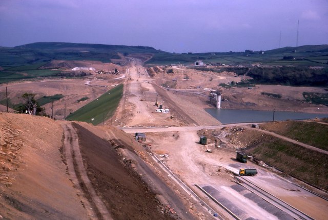
Scammonden Dam carries the M62 across the Deanhead valley between junctions 22 and 23. The Motorway Archive puts the embankment at 240 feet high. Engineering Timelines, measuring from the old valley floor, says 207. Either way it is about 4.5 million cubic yards of rockfill around a clay core with six lanes along the top, and the Archive records it as the first dam anywhere designed to carry a motorway on its crest.
The idea came from two problems in one valley. Huddersfield's water undertaking had wanted a dam there for years. The West Riding had to get a motorway across the same gap, and next door it was about to dig the Deanhead cutting, 150 feet deep and 2,600 feet long, with roughly 4.6 million cubic yards of Pennine grit to put somewhere. Tip the cutting into the valley and make the tip hold water, and both problems go away at once.
It took a private Act of Parliament, the Huddersfield Corporation Act 1965, to let a water authority build a piece of trunk road. Then, because safety was paramount, the Minister of Transport made the Corporation his agents for that stretch, with full responsibility for every aspect of the structure. For 2,000 feet, a town's waterworks was the highway authority.
Two clients, opposite instructions
What I love about this is that the two clients wanted opposite things from the same heap of rock. The highway engineers wanted a stable, free-draining, well-compacted embankment that let water out. The water engineers wanted a watertight dam with a clay core, sealed foundations and a stone face that let nothing out at all. The Archive's account of the compromise reads like a peace treaty: a thick clay seal on the upstream side, brought up layer by layer as the tipping went on, a curtain wall at the base, the valley sides benched in and sealed with more clay, and rip-rap over the lot. Rofe, Kennard and Lapworth designed the dam, Sir Alfred McAlpine built it, and the Archive notes that splitting the bill between road money and water money was no less a problem than the Act. As a former QS, I would have liked to sit in on those meetings.
Parliament worried about something else. In April 1968 Richard Wainwright asked the Minister whether the design would be reconsidered, "to ensure that vehicles will not be blown over the dam". Richard Marsh's written answer, in Hansard, was one sentence: the hazard was under detailed investigation. The ends of the cutting were shaped so that a high-sided lorry leaving the shelter of Deanhead for the open dam would not meet a wall of wind, and slatted fencing runs along both sides below carriageway level as a windbreak. Most people take it for a crash barrier.
Rain, then the Queen
The site did its best to stop them. The Archive records 66 inches of rain in the first year, roughly twice the national average. The reservoir began to fill in July 1969, by Engineering Timelines' account, and the road was carrying traffic by December 1970. The Queen came on 14 October 1971 and unveiled a plaque by the valve tower. The Archive records her saying that to construct a dam on this scale was a fine achievement, and to build a motorway across it at the same time was remarkable.
Deanhead village went under the water, and its church still stands on the bank above it. By the Archive's reckoning the stretch from the county boundary to Pole Moor came in at just under 14 million pounds in money of the day, the most expensive rural motorway in the country at the time.
The water on the far side of the fence is 52 metres deep at its deepest point, and the thing holding it in is the road you are driving on.
*Image: Scammonden Dam under construction, with the M62 corridor beyond, Richard Kay, August 1970, CC BY-SA 2.0, via Wikimedia Commons.*
Comments